| 1 results of 1 | Open Now |
Map of Walcha, NSW 2354
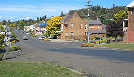
Walcha () is a town at the south-eastern edge of the Northern Tablelands, New South Wales, Australia.
The town serves as the seat of Walcha Shire. Walcha is located 425 kilometres (264 mi) by road from Sydney at the intersection of the Oxley Highway and Thunderbolts Way. The Apsley River passes through the town to tumble over the Apsley Falls before joining the Macleay River further on. Originally the river caused flooding in the town prior to a levee bank being constructed and saving the town from more floods. At the 2021 census, Walcha had a population of 1369 people.The Main North railway line is located 20.7 kilometres (12.9 mi) west at a separate village called Walcha Road which serves as the railhead. This is served by the daily NSW TrainLink Xplorer service between Sydney and Armidale. The railway line was built at Walcha Road, because it was the closest point they could get to the town, due to the steep climb over the Great Dividing Range.
Popular
Businesses
Streets
Popular businesses & services in Walcha
Graziers
Heavy Haulage
Banks & Financial Institutions
Builders & Building Contractors
Stock & Station Agents
Cafes
Chiropractor
Dentist
Employment & Recruitment Agencies
Excavation & Earthmoving Contractors
Fencing Contractors
New Car Dealers
Real Estate Agents
Second Hand Dealers
Towing Services
Tyres
Used Cars
Wool Brokers
Aboriginal & Torres Strait Islander Associations & Organisations
Accommodation Booking & Inquiry Services
Accountants & Auditors
Antiques - Auctions & Dealers
Artificial Breeding Services
Auto Electrician Services
Bakers
Businesses and services in Walcha starting with A
Streets in Walcha
(private Access)
Abbotsley Rd
Abbottsley Rd
Aberbaldie Rd
Aerodrome Rd
Angle St
Apsley Gorge Rd
Apsley River Trl
Apsley St
Ashford Rd
Baringa Rd
Bark Hut Rd
Bark Hut Trl
Beaver Pl
Bellhaven Rd
Bergen Rd
Bishop Rd
Bishops Rd
Blue Mountain Rd
Boundary St
Brackendale Rd
Brooklyn Rd
Brooks Rd
Brookside Rd
Brookvale Rd
Bukeiro Rd
Carrai Rd
Chinnocks Rd
Churchill La
Churchill St
Cicolini Trl
Cleveland Rd
Commercial La
Cotley Rd
Croudace St
Dam Acces Trl
Darjeeling Rd
Derby St
Dourallie Trl
Earles Rd
East Lynne Rd
Echo Point Rd
Emu Creek Rd
Englefield Rd
Eulo Rd
Europambela Rd
Evans St
Falls Wk
Fitzroy St
Flags Niangala Rd
Florida Rd
Geraldine Rd
Gill Rd
Glen Morrison Rd
Glenbrook Rd
Gorge Rim Cct
Gum Thee St
Hamilton St
Hartford Rd
Hazeldean Rd
Hazeldene Rd
Hill St
Hurricane Gully Rd
Jamieson St
Kilburnie Rd
Koala Wk
Kunderang Trl
Kunderrang Brook Trl
Lagoon St
Lakes Rd
Legge St
Lockyer La
Mandaloo Rd
Mcnabs Rd
Melrose La
Memorial Av
Meridian St
Middle St
Mirani Rd
Moona Plains Rd
Moonganna Rd
Niangala Rd
Niangala-walcha Rd
Nine Mile Church Rd
Nivison Rd
North St
Nowendoc Rd
Ohio North Rd
Ohio Rd
Oklahoma Rd
Old Bridle Tr
Old Brookmount Rd
Oorawilly Rd
Oxley Dr
Oxley Hwy
Oxley Wk
Pakington St
Paradise Trl
Park Av
Parkington St
Pinedale Rd
Plumbtree St
Plumtree St
Porters Camp Rd
Private Property
Quarry Rd
Queenscairn Rd
Riverglade Rd
Riverside Tr
Rosedale Rd
Rowleys Creek Rd
Ruby Hills Rd
Saleyards Rd
Sams Flat Rd
Scrubby Gully Rd
Sempill Cr
Sillwood Cl
South St
St Leonards Creek Rd
Sugarloaf Rd
Table Top Rd
Tallara Rd
The Short Spur (to Rusden Creek)
Thee St
Thunderbolts Wy
Thunderbolts Wy
Tia Diggings Rd
Tia Post Office Rd
Tiara Rd
Tiara Wk
Top Hat Rd
Topdale Rd
Towers St
Uralla Rd
Uruga Rd
Walsh St
Wauchs Rd
Weabonga Campfire Rd
Weenganimbee Rd
Willow La
Willow Tree Rd
Winterbourne Rd
Wirrabilla Rd
Wirraway Rd
Yellow St
Youmans Trl
My Whereis
Home
Set home locationWork
Set work locationSet your home and work address and access your most frequently used addresses easily.
Get quotes from your local Australian Businesses
| Our new tool powered by |
Results
Close